پرونده:Upsala Glacier, Argentina.jpg
پروندهٔ اصلی (۴٬۲۸۸ × ۲٬۸۴۸ پیکسل، اندازهٔ پرونده: ۴٫۹۱ مگابایت، نوع MIME پرونده: image/jpeg)
خلاصه
| توضیح |
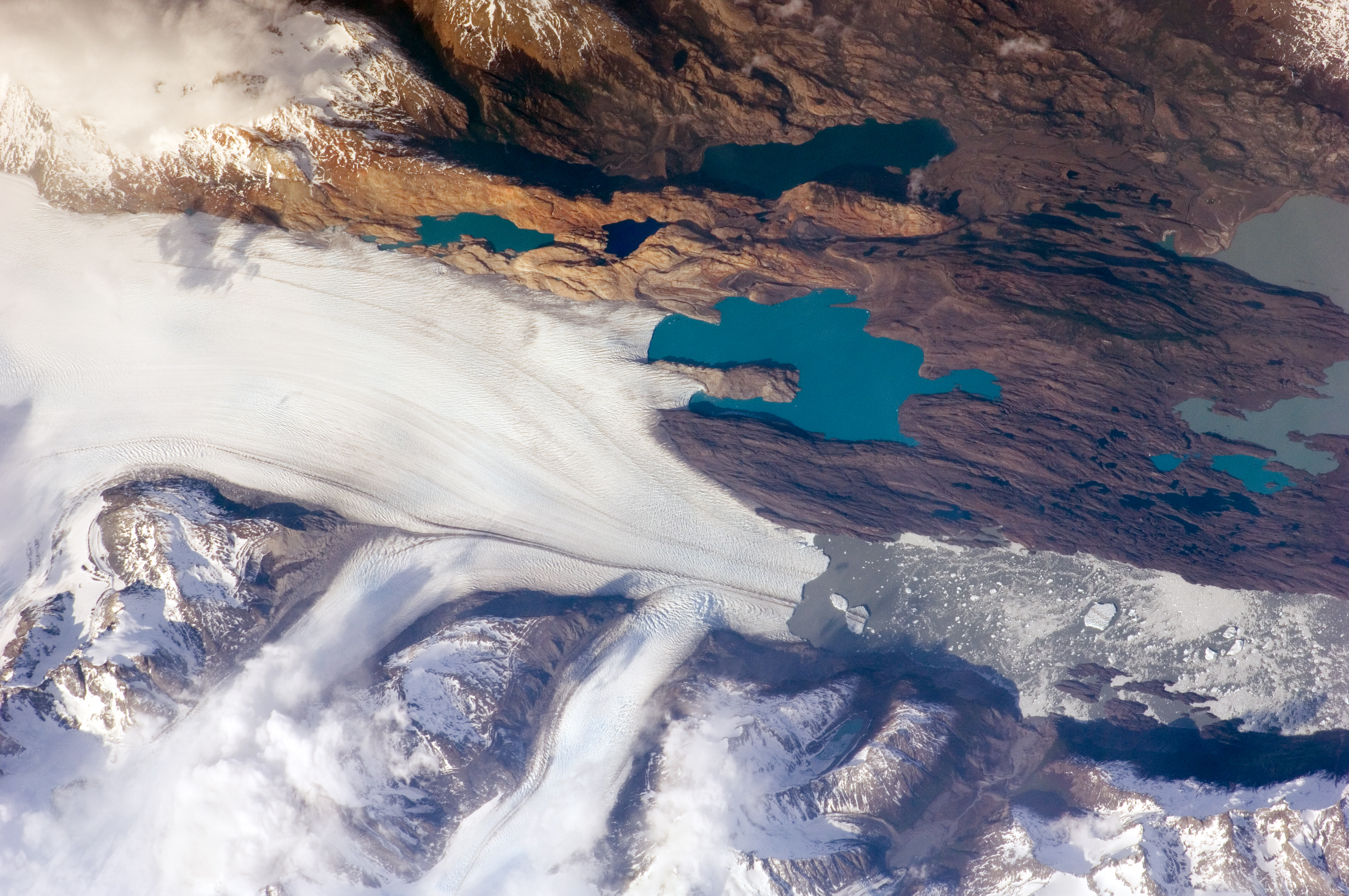
English: The Southern Patagonian Icefield of Argentina and Chile is the southern remnant of the Patagonia Ice Sheet that covered the southern Andes Mountains during the last ice age. This detailed astronaut photograph illustrates the terminus of one of the ice-field’s many spectacular glaciers—Upsala Glacier, located on the eastern side of the ice-field.
This image was taken during spring in the Southern Hemisphere, and icebergs were calving from the glacier terminus into the waters of Lago Argentino (Lake Argentina, image right). Two icebergs are especially interesting because they retain fragments of the moraine (rock debris) that forms a dark line along the upper surface of the glacier. The inclusion of the moraine illustrates how land-based rocks and sediment may wind up in ocean sediments far from shore. Moraines are formed from rock and soil debris that accumulate along the front and sides of a flowing glacier. The glacier is like a bulldozer that pushes soil and rock in front of it, leaving debris on either side. When two glaciers merge (image centre), moraines along their edges can join to form a medial moraine that is drawn out along the upper surface of the new glacier. |
| تاریخ | عکسبرداریشده در ۲۵ اکتبر ۲۰۰۹ |
| منبع | NASA Earth Observatory |
| پدیدآور |
This image was taken by the NASA Expedition 21 crew
|
| مختصات دوربین | | محل قرارگیری این نگاره و سایر نگارهها در: نقشهٔ شهری باز |
|---|
|
این نگاره یا ویدیو توسط مرکز فضایی جانسون سازمان ملی هوانوردی و فضایی (NASA)ایالات متحدهٔ آمریکا تحت شناسهٔ عکس: ISS021-E-15243کاتالوگ شدهاست. این برچست وضعیت حق تکثیر اثر ضمیمه شده را مشخص نمیکند. یک برچسپ معمولی همچنان مورد نیاز است. Commons:Licensing را برای کسب اطلاعات مشاهده فرمایید. زبانهای دیگر:
|
اجازهنامه
This file is in the public domain in the United States because it was created by the Image Science & Analysis Laboratory, of the NASA Johnson Space Center. NASA copyright policy states that "NASA material is not protected by copyright unless noted". (NASA media use guidelines or Conditions of Use of Astronaut Photographs).
Photo source: ISS021-E-15243.
|
| برچسبها | این نگاره برچسپگذاری شدهاست: برچسپها را در ویکیانبار مشاهده کنید |
تاریخچهٔ پرونده
روی تاریخ/زمانها کلیک کنید تا نسخهٔ مربوط به آن هنگام را ببینید.
| تاریخ/زمان | بندانگشتی | ابعاد | کاربر | توضیح | |
|---|---|---|---|---|---|
| کنونی | ۳ فوریهٔ ۲۰۱۷، ساعت ۱۷:۱۳ | | ۴٬۲۸۸ در ۲٬۸۴۸ (۴٫۹۱ مگابایت) | Ras67 | new rendered in high quality from NASA's raw image data (with 5500 K) |
| ۹ ژوئن ۲۰۱۰، ساعت ۰۹:۳۲ |  | ۳٬۰۷۲ در ۲٬۰۳۲ (۵٫۴۵ مگابایت) | Originalwana | higher res | |
| ۱۷ نوامبر ۲۰۰۹، ساعت ۱۱:۰۱ |  | ۱٬۴۴۰ در ۹۶۰ (۹۴۲ کیلوبایت) | Originalwana | {{Information |Description={{en|1=The Southern Patagonian Icefield of Argentina and Chile is the southern remnant of the Patagonia Ice Sheet that covered the southern Andes Mountains during the last ice age. This detailed |
کاربرد پرونده
صفحهٔ زیر از این تصویر استفاده میکند:
کاربرد سراسری پرونده
ویکیهای دیگر زیر از این پرونده استفاده میکنند:
- کاربرد در ast.wikipedia.org
- کاربرد در be.wikipedia.org
- کاربرد در bn.wikibooks.org
- کاربرد در bs.wikipedia.org
- کاربرد در cs.wikipedia.org
- کاربرد در de.wikipedia.org
- کاربرد در en.wikipedia.org
- کاربرد در en.wikiversity.org
- کاربرد در eo.wikipedia.org
- کاربرد در es.wikipedia.org
- کاربرد در fr.wikipedia.org
- کاربرد در he.wikipedia.org
- کاربرد در hr.wikipedia.org
- کاربرد در hy.wikibooks.org
- کاربرد در it.wikibooks.org
- کاربرد در it.wikiversity.org
- کاربرد در ko.wikipedia.org
- کاربرد در pl.wikipedia.org
- کاربرد در ru.wikipedia.org
- کاربرد در sh.wikipedia.org
- کاربرد در sl.wikipedia.org
- کاربرد در sv.wikipedia.org
- کاربرد در ta.wikipedia.org
- کاربرد در uk.wikipedia.org